My Year Working on Mapping the Gay Guides
This is a guest post by Dominick Bucca, a MA student in the Department of History and Geography at Clemson University. Over the course of the 2021-2022 year, Bucca was a Graduate Research Assistant on MGG. He began by transcribing a year of the Damron Guides and then moved to working with unclear entries. Here, he reflects on his experience working on a digital history project and how that influenced his own work in a class on the social history of film.
Before working as a research assistant on the Mapping the Gay Guides project (MGG), I knew very little about digital history and working with quantitative data. This lack of knowledge, however, is not to say I wasn’t exposed to digital methods. In the fall of 2020, I took Dr. Douglas Seefeldt’s “Digital Methods in Historical Studies,” a graduate-level seminar held at Clemson University that explored the ways in which digital methods can enhance how scholars of the humanities not only do research, but also how they present their scholarly findings. Although “Digital Methods” was a fascinating and informative course, I neglected to cultivate the technical skills in the months following the end of the seminar. As a result, I was somewhat behind on the digital history curve when I began working on MGG in August 2021.
Nevertheless, I quickly discovered that digital history is not that difficult to grasp. After my initial introduction to the MGG project, Dr. Amanda Regan provided a brief digital training and information session, which was geared towards preparing me for my first official task: transcribing historical information in data. Having transcribed various lectures and oral histories during my days as an undergraduate, I caught on quickly to the process of documenting the addresses listed in the Damron Address Books. But taking textual information and transforming it into clean, workable data is not an easy process: the historian must make many methodological decisions regarding how the information is presented as data.
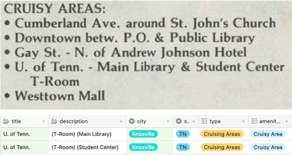
Fig. 1 Entry for Cruisy Areas on the Univ of Tenn. campus in the 1983 edition of the Bob Damron Address Book and corresponding entries in the MGG database.
A concrete example of this methodological process would be how one transcribes the colleges listed in the Damron Guides. Recorded as one entry, e.g., “U. of Tenn. – Main Library & Student Center T-Room,” the transcriber must make the methodological decision to separate the entry, creating two physical locations rather than one. On the surface, this process seems rather simplistic; yet, when examined more closely, one begins to see how separating an entry is part of a much larger methodological process of taking historical information, i.e., the Damron Guides, and transforming it into workable data.
After transcribing the addresses into a workable dataset, my second task was to geocode each entry within the datasheet. Using Google’s Geocoding API, i.e., web-based software that converts physical addresses into geographical coordinates, I attempted to locate each entry’s geographical location. My use of the former verb highlights another methodological decision I encountered while working on MGG: entries listed as “Unclear”—that is, entries that don’t have a clear physical address, e.g., “The park across the pool”—meant I had to mine the Internet for a stable geographical location.
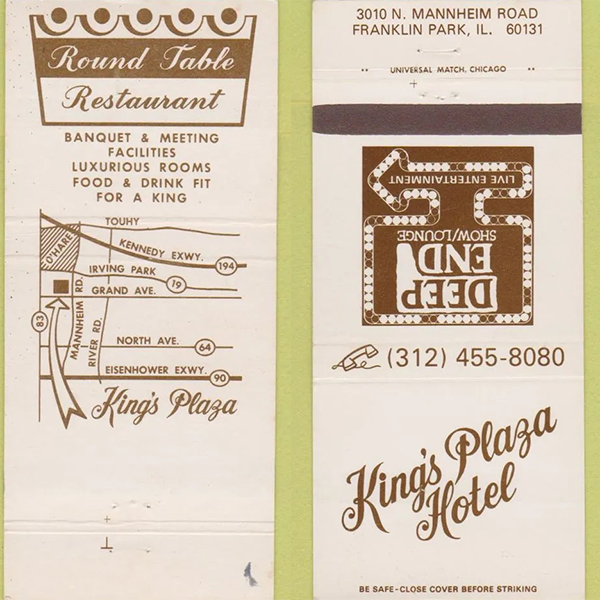
Fig. 2 A matchbook for the Kings Plaza Hotel in Franklin Park, IL.
Although I could not locate a large plurality of these locations (primarily those locations labeled as “Cruisy”), I found some entries with ease using my skills as a historian. An example I remember quite well is King’s Plaza Hotel. Listed in the Damron Guides (1985) as being somewhere in Franklin Park, Illinois, I typed the “King’s Plaza Hotel Franklin Park” into Google. Judging by the previous entries, I thought I would have a difficult time geolocating this location. However, my assumption proved wrong. The first search result displayed was a King’s Plaza Hotel matchbook for sale on eBay. Shocked, I clicked on the link only to discover a relatively clear matchbook image with an address printed across the bottom.
Many might consider this task of manually looking for physical addresses as painstaking. But being a scholar of the humanities, I found the endeavor quite fun and informative: not only did it privilege me with the opportunity to sift through large amounts of textual data (something I enjoy doing), but it also allowed me to see how many of these locations stood as cross-cultural spaces rather than entertainment venues. Furthermore, seeing how these businesses functioned as cultural spaces influenced my own research project on early (pre-1930) cinemagoing in South Carolina.
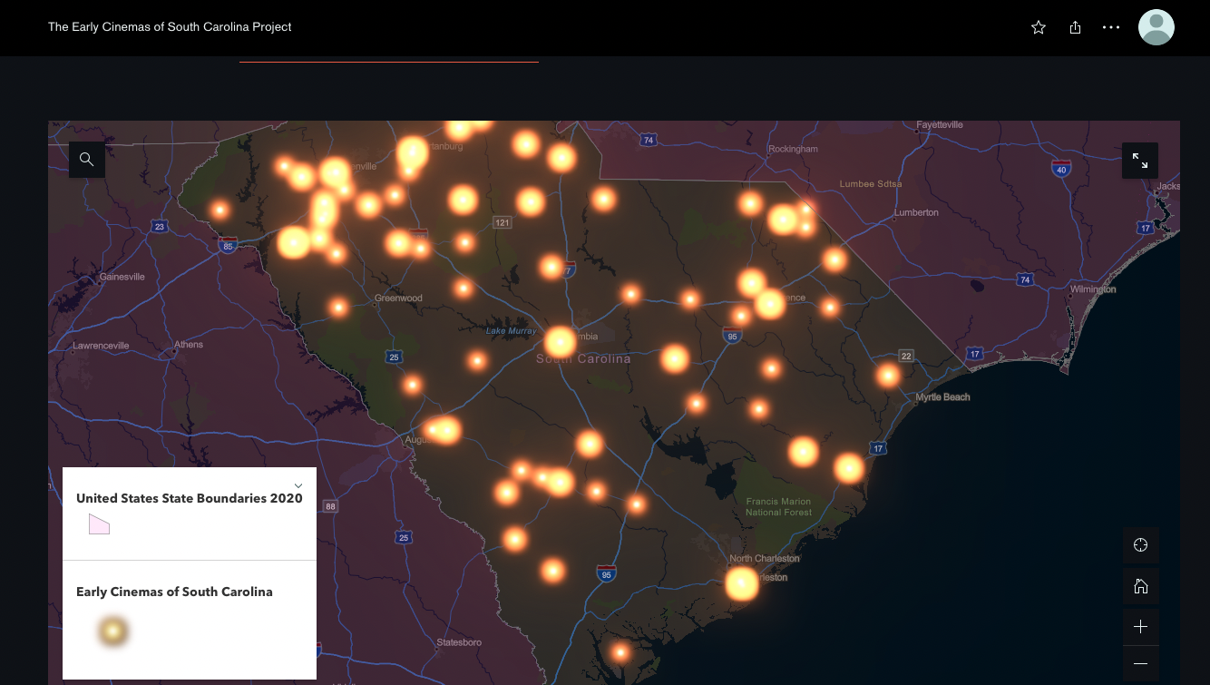
Fig. 3 A map from Bucca's digital history project entitled "The Early Cinemas of South Carolina Project."
The skills I gleaned from working on MGG helped me create my own digital project. Tasked with creating a digital database on early cinema venues in the Palmetto State, MGG served as my guide on how to document these theatrical spaces. Unable to empirically verify many of these theatrical spaces, I used the methodological process of creating a dataset and labeling each location as a “Clear” or “Unclear.” The former meant the location had an address, while the latter meant I could not geolocate the theater and thus had to use the city’s geographical coordinates as the general location. Implementing this methodological process, moreover, helped me create a vast dataset (over 190 entries), which I then used to construct The Early Cinemas of South Carolina Project, an extensive online database that attempts to document all the early cinema spaces across the Palmetto State. As the title suggests, my project shows how Black and white South Carolinians participated in the experience of early cinemagoing, a claim that complicates much of the scholarship in new cinema studies.1
In sum, as the above has shown, working on MGG has contributed significantly to my knowledge of digital history. At first unfamiliar with the workings of digital methods, I now understand how digital historians take vast amounts of historical information and convert them into clean, workable forms of computational data that can then be geocoded and used in various data visualizations. This process of data visualization is perhaps the most fascinating aspect of doing digital history: not only does it allow the historian to view her sources in a different, sometimes more critical light, but it also allows her to share both the historical data and conclusions drawn with a much broader audience, accomplishing one of the central goals of the historian.
Dominick Bucca is an M.A. student in the Department of History and Geography at Clemson University. His research interests revolve primarily around Being (temporality) and death, thus dovetailing between philosophy and intellectual history. When he’s not wrestling with the human condition, i.e., what it means to be a finite human individual on the way to extinction, one can find him hiking about the Smokey Mountains and listening to his favorite punk rock band, Against Me!.
-
Alongside Thomas Cripps, new cinema scholar Robert Allen suggests that Black southerners did not participate in public leisure culture because of rampant racism and white supremacy. For a summary of Cripps’s claim, see Arthur Knight “Searching for the Apollo: Black Moviegoing and its Contexts in the Small-Town US South,” in Explorations in New Cinema History: Approaches and Case Studies, edited by Daniel Biltereyst, Richard Maltby, and Phillippe Meers, (Blackwell Publishing, 2011), 226. For a more in-depth look at Allen’s overall thesis, see Robert C. Allen, “Race, Religion, and Rusticity: Relocation U.S. Film History,” in Going to the Movies: Hollywood and the Social Experience of Cinema, ed. Richard Maltby, Melvyn Stokes, and Robert C. Allen, (University of Exeter Press, 2007). ↩︎